The high mountain geography of the Calchaquí Valleys (Valles Calchaquíes) harbors incomparable beauty, but at the same time, it demands good planning from those who visit it. Among the unmissable destinations of this circuit in the province of Salta, the town of Cachi and Los Cardones National Park stand out. Knowing both destinations in the same itinerary allows understanding the transition of high-altitude ecosystems and the pre-Columbian and colonial history of the Argentine Northwest.
Below is all the information about routes, distances, geographical characteristics, and activities in the Salta landscapes. You will also find options for tours in Salta to complete your itinerary. And if you want to travel with everything organized, don't miss checking out our travel packages to Salta and the Argentine North.
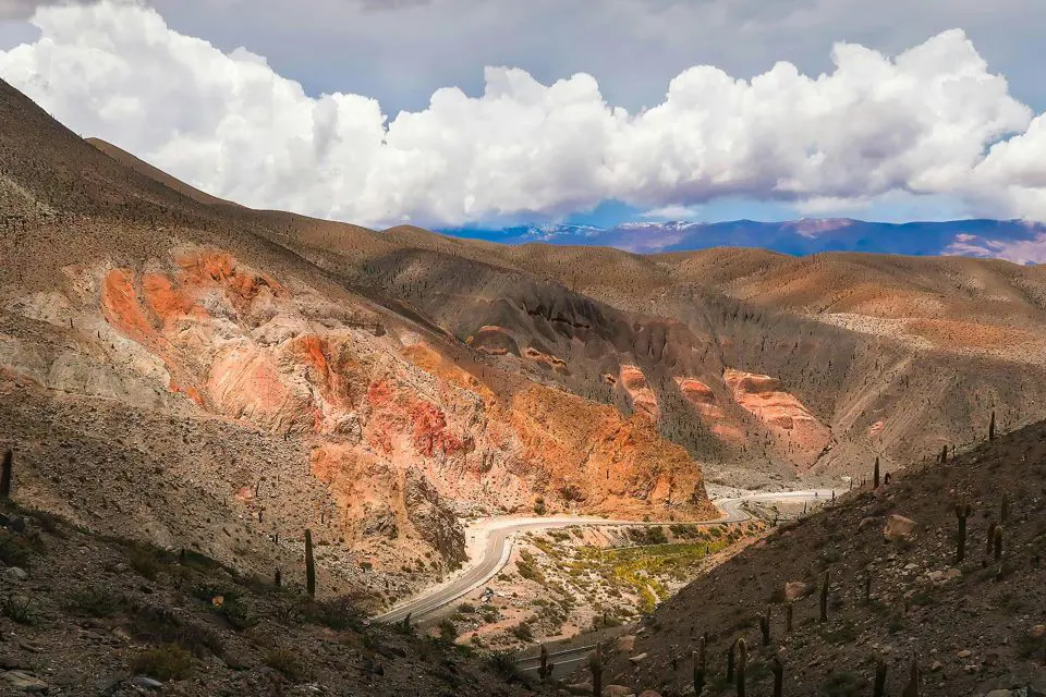
Where is Los Cardones National Park Located and How to Get There
Los Cardones National Park is in the center-west of the province of Salta, covering the departments of Cachi and San Carlos. The main access route is Provincial Route 33.
The distance from Salta to Los Cardones National Park is approximately 100 kilometers (62 miles) to its eastern limit. The journey from the capital takes about two hours of driving and requires crossing the Quebrada de Escoipe and ascending the winding road of the Cuesta del Obispo. The official entrance to the park appears at Piedra del Molino, the highest point of the slope, at 3,457 meters (11,341 feet) above sea level. Once past this point, the route crosses the Reserve through the famous Recta del Tin Tin. This is a 19-kilometer linear stretch inherited from the Inca road network (Qhapaq Ñan).
If you prefer to avoid driving on cliffside and gravel roads, the best option is to hire guided tours. The tour to La Poma, Cuesta del Obispo, and Los Cardones National Park departs from Salta, ascends the Cuesta del Obispo, crosses the cactus fields on the Recta del Tin Tin, and, instead of ending in Cachi, diverts north via Route 40 to visit the historic village of La Poma.
There, you tour the Inca Granaries (Graneros Incaicos - mud silos built under rock overhangs) and the Devil's Bridge (Puente del Diablo), a natural cavern crossed by an underground river.
How Far is Los Cardones National Park from Cachi
The distance from the urban center of Cachi to the western limit of the park (Recta del Tin Tin sector) is barely 25 kilometers (15 miles) traveling along National Route 40 and then connecting with PR 33. This is if the trip is made in reverse, with the town as the starting point.
It is important to know that Cachi is the most important urban and service center of the Upper Calchaquí Valley. Its urban layout is a reflection of colonial architecture adapted to the mountain, with narrow cobblestone streets, raised sidewalks, and whitewashed adobe houses.
What to See and Do in Cachi
Cachi is 162 kilometers (100 miles) from the provincial capital, and rises to 2,531 meters (8,303 feet) above sea level. Its epicenter is the main square. Opposite it stands the Church of San José, declared a National Historic Monument, whose architectural feature is its gabled roof built entirely with cardón (giant cactus) wood assembled without metal nails.
A few meters away is the Pío Pablo Díaz Archaeological Museum, where more than 5,000 ceramic and lithic pieces are exhibited. The museum's exhibits reconstruct the technological and social development of the pre-Inca populations of the region over 10,000 years.
The Cachi Full Day, Enchanted Valley, and Historic Center tour proposes a complete itinerary in this part of Salta. The tour departs from the capital and ascends via Provincial Route 33. Before reaching the Cuesta del Obispo, it includes a low-difficulty walk through the Enchanted Valley (Valle Encantado), a geological depression of green meadows and rocks sculpted by wind erosion. Then, it crosses Los Cardones National Park and ends with a guided walking tour through the historic center of Cachi.
If your plan is to know the depths of the Valles Calchaquíes, the Calchaquí Valleys in 2 days: Cachi and Cafayate itinerary unites the two most important poles of the area. The first day covers the ascent via PR 33, the National Park, and the visit to Cachi, where you spend the night. On the second day, the journey continues south along the mythical National Route 40 (gravel section), crossing the historic towns of Seclantás and Molinos, and traversing the striking Quebrada de las Flechas until reaching Cafayate, the wine capital of the north.
Characteristics of Los Cardones National Park
The park's protected area covers 64,117 hectares (158,436 acres). It was created in 1996 to define the confluence of four ecoregions in different altitudinal gradients: the Puna, the High Andes, the Monte of Sierras and Bolsones, and the fog grasslands (Yungas). This topographical variety generates a landscape of abrupt contrasts, dominated by exposed geological formations and arid soils.
What Los Cardones National Park Protects
The main objective of conservation is the species Echinopsis atacamensis, popularly known as cardón. Due to its hollow and light structure, cardón wood was overexploited for the construction of roofs, openings, furniture, and handicrafts. This put the species at risk, despite being an endemic species in the Andean region.
The growth rate of the cardones is extremely slow: barely between 1 and 5 centimeters per year. In this sense, a specimen can take half a century of life to produce its first white flower and generate its fruit: the pascana. The tallest specimens in the park exceed 10 meters (32 feet) and have an estimated age of 300 years.
Climate of Los Cardones National Park
The climate of Los Cardones National Park is arid high mountain, characterized by a marked daily thermal amplitude (the temperature difference between day and night can exceed 20 °C / 36 °F). Rainfall is scarce—between 100 and 200 mm annually—and is concentrated exclusively in the summer season (December to March).
For most of the year, solar radiation is extreme due to the altitude, while in winter (June to August), nighttime temperatures drop below 0 °C (32 °F), with frequent frosts and occasional snowfalls in sectors above 3,000 meters.
Flora and Fauna of Los Cardones National Park
The vegetation and animals of the park are those evolutionarily adapted to survive extreme aridity. The cardón does not grow isolated: it depends on "nurse plants" like the jarilla or the churqui, which provide shade and protection to the shoots. After the summer rains, the park's soil blooms with the appearance of the amancay. In the higher altitude zones, tolas, breas, and hard grasses (coirones) dominate.
The fauna is representative of the Andean ecosystem. Among the mammals, herds of guanacos, vicuñas, red foxes, and the puma stand out. A species of special conservation value in the area is the taruca, known as the northern huemul and declared a National Natural Monument. The Andean condor is the largest bird in the area and the king of the avifauna. It is accompanied by the cardón woodpecker, which nests in the trunks of the cacti, and some species of falcons.
Does Los Cardones National Park Have Camping?
Currently, the park does not have permitted camping areas or service infrastructure. There is no provision of drinking water, restrooms, or gas stations within the limits of the protected area. The tour is done exclusively in vehicular transit along the route, with stops at signposted viewpoints such as the Ojo del Cóndor Viewpoint or the Valle de los Guanacos Trail.
Therefore, the best options for overnight stays and stocking up are in neighboring towns. The ideal is to inquire about inns, hotels, or other forms of accommodation in Cachi or Payogasta.